![]()
“Spectacular scenery unlike any
other in the Northeast.”
| Moose River Plains Wild Forest |
| Cathedral Pines NYSDEC Trailhead |
| Eighth Lake NYSDEC Boat Launch |
| Limekiln Lake Campground, NYS DEC |
| Inlet Public Beach |

Explore by interest:
 VIEW AREA MAPS Maps of the region to view or print.
Area Maps
VIEW AREA MAPS Maps of the region to view or print.
Area Maps
 LOOKING for more information on Where to Stay and Where to Dine?
Plan Your Stay
LOOKING for more information on Where to Stay and Where to Dine?
Plan Your Stay
CARING for our favorite natural and recreational resources - See the new guide
Invasive Species Alert

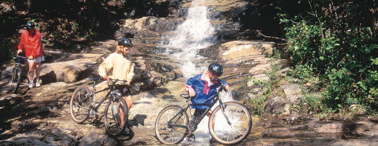
Mountain biking opportunities exist along each of the Scenic Byways, from scenic back roads to trails through the woods
Moose River Plains Mountain Biking and Snowmobiling
Central Adirondack Trail and Adirondack Trail, State Rt. 28, near Inlet in Hamilton County
Stretching more than 16 miles between the two entrance gates, these state lands comprise the largest block of remote Adirondack public land accessible by motor vehicle, mountain bike, and snowmobile.
Situated in the west central part of Hamilton County, the Moose River Recreation Area offers a multitude of recreational possibilities. The core of this area consists of 50,000 acres purchased from the Gould Paper Company in December 1963. Past logging activity and road development have had a great influence on both the natural resources of the area and use by the general public. The terrain varies from the flatness of the herb and grass plains of the Moose and Red Rivers to the gentle and often steep pitches of the adjoining forested ridges and mountains. Drainage is generally westerly or southwesterly with most ponds and streams eventually emptying into the south branch of the Moose River. Paddling along the Moose River ranges from turbo whitewater to slow meanders through isolated wilderness.
The Department of Environmental Conservation maintains over 40 miles of roads, 27 miles of trails, 140 primitive tent sites, and a firetower on Wakely Mountain. Facilities provided are minimal in keeping with the classification of the state lands. A public campground located at Limekiln Lake provides developed camping and picnic areas with modern sanitary facilities and showers. Trails are marked with round discs, three inches in diameter, in red, blue or yellow colors. Four inch orange markers designate snowmobile trails.
Bicycling is allowed on sandy and hard-packed dirt roads and some of the trails, but not on the adjacent West Canada Lakes Wilderness Area. Generally suitable for riding from mid-May to mid-October. Begin in Indian Lake on Routes 28 and 30 or 12 miles down the Cedar River Road at the Ranger Station at Wakely Dam. Also access from the west from Route 28 in the Hamlet of Inlet.
| Closest Community: | |
| Nearby Communities: | Indian Lake |
| Closest Byway: | Central Adirondack Trail and Adirondack Trail |
| Distance from Byway: | remote |
| Closest Route #: | State Rt. 28 |
| Months Occurring: | january, february, march, april, may, june, july, august, september, october, november and december |
| Best Season: | summer |
| Indoors or Outdoors: | outdoor |
| Admission Fee: | no |
| Latitude: | 43.7438167785 |
| Longitude: | -74.7828197479 |
| URL: | Moose River Plains Mountain Biking and Snowmobiling website |