![]()
“Spectacular scenery unlike any
other in the Northeast.”
| Inlet Public Library |
| Third Lake |
| Eighth Lake NYSDEC Boat Launch |
| Arrowhead Park |
| Inlet Public Tennis Courts |

Explore by interest:
 VIEW AREA MAPS Maps of the region to view or print.
Area Maps
VIEW AREA MAPS Maps of the region to view or print.
Area Maps
 LOOKING for more information on Where to Stay and Where to Dine?
Plan Your Stay
LOOKING for more information on Where to Stay and Where to Dine?
Plan Your Stay
CARING for our favorite natural and recreational resources - See the new guide
Invasive Species Alert

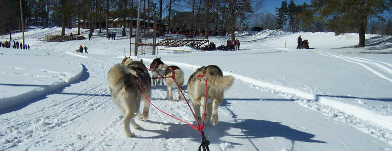
Nothing like alittle exercise on a winter's day along the Adirondack North Country Scenic Byways (by Teri Ellis)
Moose River Plains Wild Forest
Central Adirondack Trail and Adirondack Trail, State Rt. 28, near Inlet in Hamilton County
Located south of Route 28 and north of the West Canada Lakes Wilderness, with most foot trails leading to a pond or lake.
The majority of foot trails lead to a pond or lake and begin at the end of short spur roads. The main road through the area is dirt or gravel and 23 miles long from Limekiln gate south of Inlet to Cedar River Flow just north of Indian Lake.
Some of the hikes include:
Sly Pond Trail, 5.4 miles, climbs a portion of Little Moose Mt. before descending to Sly Pond, one of the highest bodies of water in the Adirondacks.
Lost Ponds Trail, 1.0 mile, leads to a stillwater area on Sumner Stream and continues to a popular fishing pond.
Hell Diver Pond Trail, .25 mile, provides easy access or a short canoe carry to this attractive pond.
Mitchell Ponds Trail, 2.8 mile, starting with a two mile walk to the first pond beginning along an old roadway. The trail then continues on the peninsula between the two ponds and officially ends at a natural rock dam.
Rock Dam Road, 4.3 miles, starting on the Red River Bridge intersection to the barrier at the end of the Rock Dam Road.
Whites Pond Trail, 1.9 miles, with the trail accessible from the Limekiln Lake campground by boat.
Rock Dam Trail, 1.4 miles, ends at a long rock formation across the confluence of the South Branch of the Moose River and the Red River.
Otter Brook Road, 3.3 miles starting from main T road intersection to Otter Brook barrier.
Ice House Pond Trail, .4 mile, follows an old road which makes an easy hike or short canoe carry to this kettle bog pond.
Beaver Lake Trail, 2.3 miles, starts at a parking area and road barrier just west of the Moose River Bridge. The trail follows an old road to the northern shoreline of the lake. The lake is named for its odd shape which resembles a beaver.
Otter Brook Trail, 9.0 miles, an unmaintained old road provides access to a portion of the northern boundary of the West Canada Lake Wilderness Area. Marked foot trails lead to Lost Pond and Cedar Lakes.
Indian Lake Road, 5.5 miles starting from the Otter Brook Road intersection to Barrier near Indian Lake. This road may be temporarily closed early in the season at the Otter Brook Barrier.
These short trails provide easy access to each respective water body: Squaw Lake Trail at 0.4 mile; Muskrat Pond Trail at 0.1 mile; and Indian Lake Trail at 0.1 mile.
| Closest Community: | |
| Nearby Communities: | Indian Lake |
| Closest Byway: | Central Adirondack Trail and Adirondack Trail |
| Distance from Byway: | remote |
| Closest Route #: | State Rt. 28 |
| Months Occurring: | may, june, july, august, september and october |
| Best Season: | summer |
| Indoors or Outdoors: | outdoor |
| Admission Fee: | no |
| Latitude: | 43.70047884 |
| Longitude: | -74.7902713816 |
| URL: | Moose River Plains Wild Forest website |